Liability Disclaimer:
The information provided in this article is for general informational purposes only and is based on publicly available data, industry experience, and typical roadway conditions within the referenced corridors. Conditions on highways and roadways can change rapidly due to weather, construction, traffic incidents, and other unforeseen factors. This content is not intended to serve as professional driving, safety, or regulatory advice. Drivers, fleet operators, and dispatchers are solely responsible for exercising their own judgment, complying with all applicable laws and regulations, and adjusting operations based on real-time conditions. All Star Heavy Haul & Towing, Inc makes no representations or warranties, express or implied, regarding the completeness, accuracy, or reliability of the information contained herein. Under no circumstances shall All Star Heavy Haul & Towing, Inc be liable for any direct, indirect, incidental, consequential, or punitive damages arising from the use of, or reliance on, this content. References to specific roadways, hazards, or operational strategies are illustrative and should not be interpreted as guarantees of conditions or outcomes. Availability and response times for towing, recovery, or roadside services may vary based on location, weather, traffic, and resource demand. By using this information, you acknowledge and agree that all operational decisions and associated risks remain your sole responsibility.
The freight corridor connecting Livermore and Pleasanton on the west to Tracy, Manteca, and Patterson on the east is one of the most demanding stretches of road in the California Central Valley — and one of the most unforgiving for 18-wheelers. Within roughly 60 miles, a loaded combination vehicle crosses Altamont Pass, navigates the high-volume I-205/I-580 interchange, drops onto I-5, and pushes south toward Patterson and Crows Landing. Each of those segments carries its own set of conditions that can transform a routine haul into a recovery call. Understanding the specific hazards at each point on this corridor helps drivers, dispatchers, and fleet managers prepare — and know what resources are available when things go wrong.
Altamont Pass: Grades, Wind, and the Eastbound Descent on I-580
Altamont Pass sits at the heart of the I-580 corridor and is the single most consequential geographic feature between the Bay Area and the Central Valley for commercial freight. The terrain creates a set of stacked hazards that affect 18-wheelers differently depending on direction of travel, load configuration, and season.
Eastbound I-580 is the more technically demanding direction. The roadway descends through the pass with steep grades and curves that require careful speed management on a fully loaded combination vehicle. The eastbound lanes feature a significant downgrade with curves where speed control is critical for heavy vehicles. Grades on this descent are steep enough that runaway truck concerns are real — not theoretical.
Wind is the other variable that defines Altamont Pass. The pass exists precisely because it is a natural gap in the Coast Range hills, and that gap channels Bay Area marine air eastward with considerable force. The wind farm visible from I-580 exists for the same reason: this is one of the windiest land corridors in Northern California. High-profile vehicles — particularly empty or lightly loaded trailers — are most vulnerable. Crosswinds that push a high-profile vehicle off its lane track occur throughout the year but are most intense during spring and summer when the thermal pressure differential between the coast and the Central Valley is greatest. Crosswinds at highway speeds on a high-sided trailer can produce lateral loads that challenge steering and, in worst-case scenarios, contribute to rollover events.
- Eastbound descent grades and curves — speed management is critical; the grade begins well west of the valley floor
- Crosswind exposure — the pass channels prevailing winds directly onto the broadside of high-profile trailers
- Empty or lightly loaded trailers — a high center of gravity and low ballast weight make empty boxes significantly more susceptible to lateral wind forces
- Storm-related pavement damage — retaining walls and roadway sections on I-580 over Altamont Pass have historically sustained storm damage that narrows lanes and creates surface irregularities for heavy vehicles
- Patterson Pass Road as a detour non-option — when I-580 is closed or heavily restricted, Caltrans has noted that Altamont Pass Road is not suitable for large trucks due to its narrow, winding character; drivers should be prepared to stage and wait rather than seek a road detour
The I-205 / I-580 Interchange Near Tracy: High-Stress Merge Territory
Just east of Altamont Pass, the freeway splits into one of the most heavily trafficked interchange zones in the northern San Joaquin Valley. I-205 branches east-northeast toward Tracy while I-580 continues southeast toward I-5. This transition zone — where an eight-lane freeway separates into two four- to six-lane segments — is a concentrated stress point for 18-wheelers.
I-205 runs across the north side of Tracy and connects to I-5 north through Lathrop and to SR 120 east toward Manteca. The freeway carries heavy commuter and freight traffic simultaneously, and the segment between the I-580 split and I-5 has historically seen congestion during peak hours. For an 18-wheeler, merging, lane-changing, and maintaining following distances in stop-and-go conditions in this zone places added mechanical stress on drivetrain, brakes, and tires — particularly after already running the Altamont descent.
Fleet managers routing loads through this junction should be aware that on westbound I-580 there is a designated truck bypass lane configuration near the I-205 interchange — a legacy of infrastructure improvements completed in 2008–2009 — that separates mainline traffic from truck movements. Understanding this configuration in advance reduces the likelihood of a driver making a late lane decision at speed.
18-wheeler towing on the I-580 and I-205 corridor →
Tule Fog on I-5 From Tracy Through Patterson and Crows Landing
Once a driver clears the Tracy interchange and heads south on I-5 toward Patterson and Crows Landing, the dominant seasonal hazard shifts from wind and grades to tule fog. Tule fog is a thick ground fog that settles across the San Joaquin Valley from late fall through early spring — officially from November 1 to March 31 — forming after significant rainfall when winds are calm, humidity is high, and ground temperatures drop overnight.
Tule fog has historically been the leading cause of weather-related accidents in California. Because the Central Valley is effectively a bowl surrounded by mountain ranges on multiple sides, once tule fog forms, the surrounding terrain traps the cold air in place. The dense, immobile fog can persist for days or even weeks without disruption. Visibility along I-5 in this corridor can deteriorate to near-zero conditions, and the National Weather Service has issued near-daily Dense Fog Advisories along I-5 during severe tule fog events, warning of 'very high transportation risk.'
For 18-wheelers, tule fog presents a compounding risk: stopping distances for a fully loaded combination vehicle are already long under ideal conditions. When visibility is measured in tens of feet rather than hundreds of yards, the gap between a driver's perception of hazard and the truck's ability to stop shrinks to almost nothing. Multi-vehicle pile-ups involving big rigs in tule fog conditions are a recurring event along the I-5 corridor in the Central Valley — a statistical fact that fleet managers and dispatchers need to build into winter routing and scheduling decisions.
- Formation window: November through March — plan for fog exposure on any overnight or early-morning I-5 run during this period
- Zero-visibility pockets form suddenly — conditions can deteriorate within seconds, even in areas where fog appeared light moments earlier
- Freezing drizzle accompanies some events — tule fog episodes occasionally include freezing drizzle that can leave black ice on the roadway surface
- Fog does not lift uniformly — patches of dense fog can persist long after adjacent sections have cleared; a driver who clears one fog bank may run directly into another
- High beams make conditions worse — light reflects off the fog layer and reduces forward visibility further
- I-5 between Tracy and Crows Landing has no meaningful alternate route — when conditions deteriorate severely, the only safe option is to find a safe staging location and wait
Highway 132 and the Approach to Patterson: Secondary Hazards Fleet Managers Overlook
Highway 132 connects Modesto to the I-5 corridor and serves as an alternate routing option for loads moving between the Central Valley interior and the Tracy/Livermore corridor. While it does not carry the freight volume of I-5 or I-205, it is used by 18-wheelers — particularly those serving agriculture and aggregate industries in the western San Joaquin Valley. The road passes through terrain that experiences the same tule fog conditions as I-5 in winter, and its rural character means breakdown staging options are more limited.
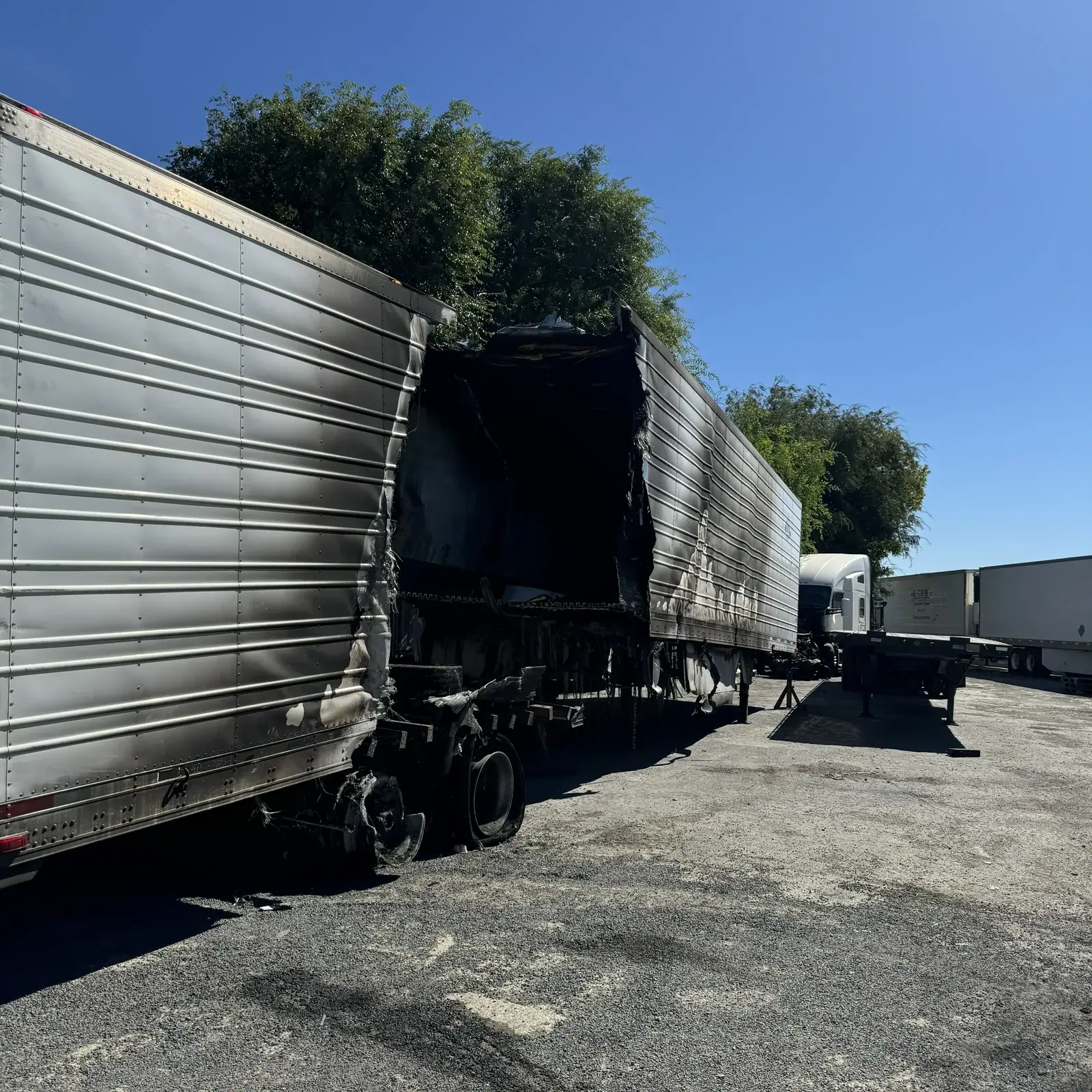
The I-5 segment approaching Patterson from the north is a transition zone where Central Valley agricultural and industrial traffic merges with north-south through freight. This area — including the approaches to Crows Landing — sees a mix of heavily loaded agricultural haulers, refrigerated units, and through-traffic semis. The combination of loaded weight, variable road surfaces, and seasonal fog conditions makes this one of the stretches in the service area where a breakdown has the highest secondary consequence: limited shoulders, high approach speeds, and minimal staging room compound the recovery challenge when an 18-wheeler goes down.
I-680 Through Pleasanton and Livermore: The Western Edge of the Corridor
I-680 touches Pleasanton and intersects with I-580 in the Tri-Valley area, serving as the western boundary of the All Star service area. For 18-wheelers transiting between the I-680 corridor and the Central Valley, the I-580/I-680 interchange in the Pleasanton/Livermore area is a critical transition point. Traffic density in this interchange zone is high during commute hours, and commercial vehicle operators entering or exiting I-580 westbound here must account for the truck weight restriction that applies to a downstream section of I-580 — the ban on trucks over 4,500 lbs that applies between Foothill Boulevard in San Leandro and Grand Avenue in Oakland requires Central Valley–bound freight to use I-580 only as far as the Altamont Pass approach.
Breakdowns on I-680 in the Pleasanton segment present recovery challenges distinct from I-5 or I-205 events: the terrain is more constrained, and the surrounding urban and suburban infrastructure limits the approach angles available to heavy recovery equipment. Knowing that a properly equipped heavy wrecker is staged in the Tracy/Manteca corridor — within practical response distance of both I-680 at Pleasanton and I-5 at Crows Landing — is directly relevant to how quickly a dispatch call turns into a cleared scene.
What This Corridor Means for 18-Wheeler Recovery Response
The geography of this corridor — a mountain pass, a complex interchange, 60-plus miles of fog-prone valley floor, and a terminal interchange at Pleasanton — means that the type of incident an 18-wheeler is likely to experience varies significantly by segment. A wind-assisted rollover on the Altamont descent is a different recovery operation from a fog-related rear-end on I-5 south of Tracy, which is a different operation from a mechanical breakdown staged on the narrow shoulder approaching Patterson.
Effective 18-wheeler recovery on this corridor requires equipment that can handle a full range of scenarios: rotator cranes for rollover and off-road recovery, heavy wreckers capable of a straight tow on a breakdown, and Landoll trailers for transport when the tractor is not driveable. It also requires a response time that reflects the actual geography — a unit staged in Tracy can reach any point on this corridor significantly faster than one dispatched from outside the San Joaquin Valley.
Dispatchers and fleet managers who regularly move freight through the Livermore–Tracy–Patterson corridor benefit from having a heavy-duty towing contact pre-established before the call needs to happen. When an 18-wheeler goes down on I-5 in tule fog at 0300 hours or rolls on the Altamont eastbound descent, the last thing a dispatcher needs is to start vetting providers from scratch.
This article is for general informational and educational purposes only and does not establish operating procedures or requirements for All Star Towing drivers. All drivers must follow current company policies, training materials, and applicable law.
commercial fleet towing accounts and priority dispatch →